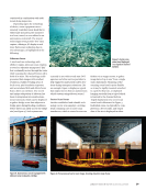
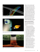
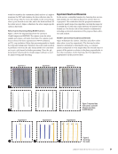
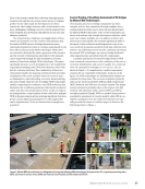
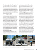
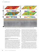
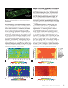
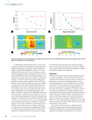
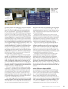
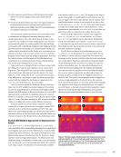
plan or elevation view. Figure 6 illus- trates an elevation view output image. Multiple plan view images can be post-processed as mosaics to cover large areas of concern (see Figure 7), while elevation scans of individual bridge piers can be post-processed to show image views combining above- and below-water portions of a bridge pier as though they were a single photograph (see Figures 6 and 11 for reference). Scanning sonar software allows image data to be interrogated in real time, so as to calculate distances and dimensions of elements or defects and display them directly on the output images without the need for additional post-processing. Sector scanning sonar has been used during underwater bridge inspections for many years and plays a fundamen- tal role in the industry today, for both diver safety and inspection data acqui- sition. For example, prior to deploying an inspection diver, multiple plan view scans can be taken around the perim- eter of a pier to quickly establish “safe zones” for subsequent diver deploy- ment in areas free of drift and debris. Additionally, the angular range of the scan can be narrowed to focus in on a specific “swath” or area of concern. Thus, the sonar can be operated once the diver has entered the water to track them in real time as they conduct the inspec- tion. Several state DOT agencies require acoustic imaging of bridge substructure elements as a part of their underwa- ter bridge inspection procedure, and post-processed sector scan images are a common deliverable for those owners. Multibeam Sonar Unlike single beam sonar, which uses just one transducer to map the channel bottom, a multibeam sonar sends out multiple, simultaneous sonar beams from multiple transducers in a fan- shaped pattern. This covers the space both directly under the inspection boat and out to each side. Multibeam sonars interrogate the channel bottom and also collect returns from features that reflect sound in the water column. Water column backscatter data can be used to reveal objects in the water column, including the bridge substruc- ture. Computers on the inspection boat collect and post-process the data to create colorful two- or three-dimensional bathymetric (water depth) maps as well as sonar images of the substructure elements (see Figure 8). As with sector scan, multibeam sonar is frequently used in the underwater bridge inspection industry due to its efficiency and data quality. Multibeam sonar is also used for obtaining bathymetry used for hydraulic modeling, such as SRH-2D modeling, as currently promoted by FHWA. Volumetric 3D Imaging Sonar Volumetric 3D imaging sonar is one of the newest, most high-tech sonar technologies available, yielding high-accuracy, high-resolution data images displayed in real time. This technology provides instantaneous 3D images, producing detailed GPS- referenced underwater scans in real time, with comprehensive measure- ment capability (see Figure 9). This technology also allows for monitoring moving objects underwater in real time (like watching a “sonar movie”), thus allowing monitoring of a diver at work in zero-visibility water. Another key advantage of volumetric 3D sonar is that it offers a more intuitive operation and significantly reduced post-processing time as compared to competing sonar technologies. As with multibeam sonar, volumetric 3D imaging sonar can also be used as an integral part of a hydro- graphic survey system. ROV Inspection Underwater ROV inspection also has roots in the deep-water offshore oil and gas industry. Over the years, however, ROVs have been developed that are FEATURE | UNDERWATERINSPECTION Figure 7. Plan view mosaic of channel bottom surrounding bridge pier using sector scan. Figure 8. Multibeam image of bridge pier, showing bottom topography. 40 M AT E R I A L S E V A L U AT I O N • J A N U A R Y 2 0 2 3 2301 ME Jan New.indd 40 12/20/22 8:15 AM COURTESY: KONGSBERG MARITIME

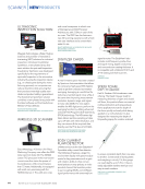
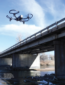
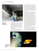
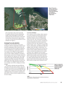
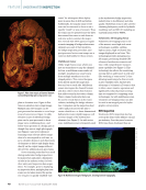
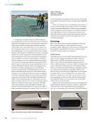
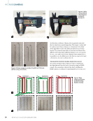
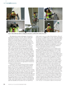
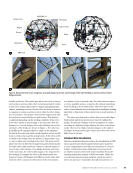
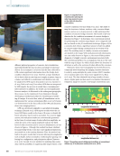
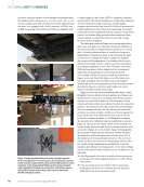
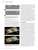
lighter, more agile, and easier and less expensive to own and operate. While early inland-oriented units were primar- ily “flying photo/video cameras” with limited mobility, today’s inspection ROVs are capable of operating against river flow velocities commonly experienced during underwater bridge inspections and employ multiple thrusters oriented to yaw the vehicle into proper position to inspect the element. Today’s ROVs are smaller (some less than 12 in. [30.5. cm] in diameter to fit into confined spaces) and offer integral mounting of a sonar imaging head or UTT transducer (see Figure 10). As such, ROVs can be used in lieu of crewed commercial diving for select inspection operations, such as working in polluted waters, or in conjunc- tion with convention diving operations. Modern Inspection Procedures A few scenarios illustrate the benefits of integrating imaging sonar and/or ROVs with conventional diving-based inspection: Ñ A sector-scanning, multibeam, or volumetric 3D sonar system or sonar-enabled ROV can be used by a dive team to preview piers to evaluate potential hazards, such as drift/debris accumulations, prior to deploying a diver (see Figure 11). This significantly increases inspection efficiency and enhances safety by allowing the dive team to preplan the inspection of each individual bridge pier. Using the appropriate technology, this “pre-inspection sonar scan” can be quickly accomplished as a first step in the inspection process. Ñ This same sonar system or ROV could then be used to monitor divers’ progress and help ensure diver safety during the inspection. With adequate water clarity, the ROV could also provide video of the inspection. This “over-the-shoulder supervision” approach is common practice offshore and allows topside personnel to collaborate with and direct the diver. Ñ Sonar and ROVs can be used to help evaluate confined spaces, such as areas of foundation undermining, Figure 9. Volumetric 3D sonar image of bridge pier. Figure 10. ROV with mounted UTT transducer. Figure 11. Drift at pier foundation easily detected using sector scanner sonar. J A N U A R Y 2 0 2 3 • M AT E R I A L S E V A L U AT I O N 41 2301 ME Jan New.indd 41 12/20/22 8:15 AM COURTESY: CODA OCTOPUS PRODUCTS LTD. COURTESY: RICH ARRIETA, NAVAL INFORMATION WARFARE CENTER
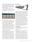
ASNT grants non-exclusive, non-transferable license of this material to  .
All rights reserved. © ASNT 2026. To report unauthorized use, contact: customersupport@asnt.org