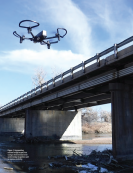
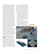
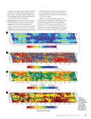
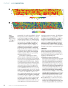
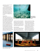
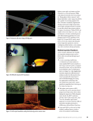
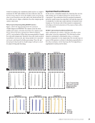
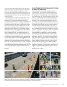
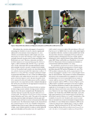
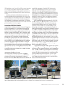
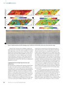
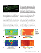
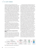
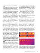
different physical properties of concrete, data visualization may help identify the exact location and shape of structural defects. As an example, it is known that the data collected by GPR contain significant information about the bridge deck condition (Tarussov et al. 2013). However, a major drawback of it is that its data in raw form are complex in nature, large in volume, and difficult to understand, and therefore can only be analyzed by GPR experts (Gucunski et al. 2013 Tarussov et al. 2013 Dinh et al. 2019). Even when GPR data are interpreted by GPR experts, the process is usually time-consuming and labor-intensive. In addition, the results can vary significantly between analysts. As illustrated in the subsequent paragraphs, these issues can be minimized, if not eliminated, through developing a standard procedure for visualizing and analyz- ing 3D images. It is noted that, while 3D visualization can be implemented for various technologies (Kim et al. 2017), herein it is demonstrated in the data collected by GPR and ultrasonic shear wave imaging devices. GPR was developed originally as a geophysical imaging technique (Daniels 2004). GPR experts would review the col- lected GPR data, usually in the form of B-scans, to identify dif- ferent subsurface layers and/or anomalies. For concrete appli- cations, the evaluation results are conventionally presented in the form of contour maps of rebar reflection amplitude, on which the areas of low signal amplitude indicate the likeli- hood of rebar corrosion and/or concrete delamination, as was shown in Figure 4. Although this method has been validated for many bridge decks, it also has some significant limitations, as pointed out in the existing literature. First, the method can lead to deceptive results due to factors affecting the amplitudes such as depth, surface anomalies, reinforcing bar spacing, rein- forcing bar configuration, and polarization effects (Tarussov et al. 2013). Second, it is not suitable for analyzing time-series data with the possibility of suggesting false improvement of the concrete condition over time (Dinh et al. 2015). The ability to map the locations of rebars, tendons, voids, concrete delami- nations, and so on, is of great interest to fully understand the condition of concrete bridge elements. The benefit of 3D visu- alization for the condition assessment of concrete bridges is illustrated in Figure 7. In this figure, the conventional method for presenting the condition map (Figure 7a) is compared with the one based on the 3D visualization technique (Figure 7b) for a concrete deck where a significant amount of salt was added to concrete mixes during construction in one section of the deck. The resulting areas of a highly corrosive environment are marked on the maps. With such ground-truth information, one can easily observe in Figure 7a, the areas of false-positive diagnosis of a highly corrosive environment associated with the conventional method. As a comparison, that is not the case with the map in Figure 7b, which clearly shows the locations of all rebars as well as the sections of rebars affected by corrosion. Ultrasonic shear wave tomography has recently become a commonly used technology for imaging concrete structures. It works by using multiple dry-point-contract (DPC) transduc- ers to transmit and receive shear wave signals (De La Haza et al. 2013). The data obtained from a large number of trans- ducer couples/pairs are then used to reconstruct the interior/ volumetric image of concrete. A 3D image created from such ME | NDEOFBRIDGES Figure 7. Presenting concrete bridge deck condition: (a) conventional method (b) 3D visualization method (Dinh et al. 2019). Attenuation (dB) Longitudinal distance (m) 0 1 2 3 4 5 6 7 8 9 3 2 1 0 0 –1 –2 –4 –6 –8 –10 –12 –14 –20 Areas of corrosive environment Areas of corrosive environment 0 1 2 3 4 5 6 7 8 9 3 2 1 0 Longitudinal distance (m) Figure 6. A snapshot from a recorded video taken by the robot. Two zoomed-in areas on the right side show the crack location. 62 M AT E R I A L S E V A L U AT I O N • J A N U A R Y 2 0 2 3 2301 ME Jan New.indd 62 12/20/22 8:15 AM Lateral distance (m) Lateral distance (m)

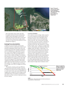
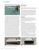
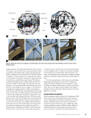
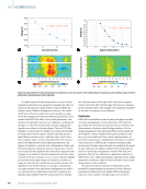
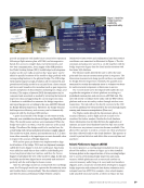
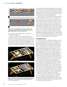
data for a section of the above concrete bridge deck specimen is shown in Figure 8. The image clearly shows the locations and shapes of simulated delamination, which was embedded into the deck during construction. It is worth noting that a delam- inated area caused by corrosion is displayed in the image. This area coincides with an area of the corrosive environment depicted in Figure 7. The delamination is visible in the 3D image created from the ultrasonic shear wave data. The same is not the case with the one reconstructed from the GPR data. According to Dinh and Gucunski (2021), some factors might affect the vis- ibility of delamination in GPR images such as the thickness of delamination, antenna frequency, signal attenuation, the prox- imity of steel bars, and so on. On one side, this indicates the need for using multiple NDE technologies for a comprehensive evaluation of concrete bridge elements. On the other side, which is of more interest to this section, it showcases the benefits of 3D visualization of NDE data for concrete bridges. Improved Interpretation of Multi-NDE Technology Data It has been recognized that NDE results may be affected by many parameters such as the degree of saturation, concrete cover, delamination depth, and similar. For example, Robles et al. (2022) summarized the effects of multiple parameters, including temperature, the presence of steel reinforcement, cracks and delamination defects, specimen geometry, and concrete composition on ER results. Because of that, cor- rections including the effects of those parameters should be incorporated to improve the data interpretation, which can be achieved through a joint analysis of results from multiple NDE technologies. The joint analysis approach is illustrated for the HCP data collected on a bridge specimen at the BEAST (Bridge Evaluation and Accelerated Structural Testing) facility at Rutgers University. The measured potential of corrosion activity is, among others, affected by the moisture content of concrete, concrete cover thickness, presence and moisture condition of delamination, and electrical resistivity of concrete. The four parameters can be evaluated using different NDE technologies, as illustrated in Figure 9. For example, the Moist- SCAN device (Goeller and Jungstadt 2018) was used to estimate the degree of saturation of the concrete slab, as shown in Figure 9a. On the other hand, the concrete cover thickness was obtained from the GPR survey, as shown in Figure 9b. The IE results provide information about the delamination location and depth, as shown in Figure 9c. In addition, the results of ER measurements, as shown in Figure 9d, have been taken into consideration to correct the HCP measurement results. Simulated delamination Corrosion-induced delamination Figure 8. 3D visualization of bridge deck specimen from ultrasonic shear wave data. Figure 9. NDE maps for the BEAST slab: (a) degree of saturation (b) concrete cover (c) delamination (d) electrical resistivity. 0 10 20 30 40 50 60 70 80 90 100 21 17 13 9 5 1 1 5 9 13 17 21 25 29 33 37 41 45 49 21 17 13 9 5 1 1 5 9 13 17 21 25 29 33 37 41 45 49 21 17 13 9 5 1 1 5 9 13 17 21 25 29 33 37 41 45 49 21 17 13 9 5 1 1 5 9 13 17 21 25 29 33 37 41 45 49 Sound Fair Poor Serious Longitudinal distance (ft.) 1 1.25 1.5 1.75 2 2.25 2.5 2.75 in. Longitudinal distance (ft.) 0 10 20 30 40 50 60 70 kOhm Longitudinal distance (ft.) Longitudinal distance (ft.) % J A N U A R Y 2 0 2 3 • M AT E R I A L S E V A L U AT I O N 63 2301 ME Jan New.indd 63 12/20/22 8:15 AM Transverse distance (f Transverse distance (f Transverse distance (f Transverse distance (f
ASNT grants non-exclusive, non-transferable license of this material to  .
All rights reserved. © ASNT 2026. To report unauthorized use, contact: customersupport@asnt.org